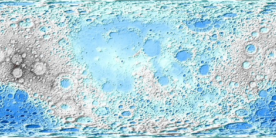
USGS Moon Relief

Usage
You access the Moon LOLA relief grid by specifying the special name
@moon_relief[_rru[_reg]]
This grid contains observed relief measured via altimetry. The following codes for the optional rru and reg are supported (dimensions are listed for pixel-registered grids; gridline-registered grids increment dimensions by one):
Code |
Dimensions |
Reg |
Size |
Description |
|---|---|---|---|---|
01d |
360 x 180 |
g,p |
122 KB |
1 arc degree Moon relief (LOLA @ 168 km) |
30m |
720 x 360 |
g,p |
423 KB |
30 arc minute Moon relief (LOLA @ 84 km) |
20m |
1080 x 540 |
g,p |
897 KB |
20 arc minute Moon relief (LOLA @ 56 km) |
15m |
1440 x 720 |
g,p |
1.5 MB |
15 arc minute Moon relief (LOLA @ 42 km) |
10m |
2160 x 1080 |
g,p |
3.3 MB |
10 arc minute Moon relief (LOLA @ 28 km) |
06m |
3600 x 1800 |
g,p |
8.5 MB |
6 arc minute Moon relief (LOLA @ 17 km) |
05m |
4320 x 2160 |
g,p |
12 MB |
5 arc minute Moon relief (LOLA @ 16 km) |
04m |
5400 x 2700 |
g,p |
18 MB |
4 arc minute Moon relief (LOLA @ 11 km) |
03m |
7200 x 3600 |
g,p |
31 MB |
3 arc minute Moon relief (LOLA @ 8.4 km) |
02m |
10800 x 5400 |
g,p |
68 MB |
2 arc minute Moon relief (LOLA @ 5.6 km) |
01m |
21600 x 10800 |
g,p |
253 MB |
1 arc minute Moon relief (LOLA @ 2.8 km) |
30s |
43200 x 21600 |
g,p |
937 MB |
30 arc second Moon relief (LOLA @ 1.4 km) |
15s |
86400 x 43200 |
g,p |
3.3 GB |
15 arc second Moon relief (LOLA @ 0.7 km) |
14s |
106694 x 53347 |
p |
3.9 GB |
14.06… arc second Moon relief (LOLA original) |
Note that resolutions 05m and higher are tiled. See Remote Datasets for more information.
See GMT remote dataset usage for when resolution codes are optional or required.
All of these data will, when downloaded, be placed in your ~/.gmt/server directory, with
the moon_relief files being placed in an moon/moon_relief sub-directory. If you
do not specify a CPT then the default CPT for this dataset (the GMT master @moon_relief.cpt CPT) will be used.
Examples
To create a PDF map of the Moon LOLA relief at 1 arc degree resolution, try:
gmt grdimage @moon_relief_01d -Baf -pdf moon_relief
Technical Information
As you see, the 15s and lower resolutions are all derivatives of USGS’ 14.0625 arc-second Lunar_LRO_LOLA_Global_LDEM_118m_Mar2014.tif (Mazarico_et_al., 2013). We have downsampled it via Cartesian Gaussian filtering to prevent aliasing while preserving the latitude-dependent resolution in the original 14.0625 arc sec grid. The full (6 sigma) filter-widths are indicated in parenthesis. Almost all grids are available in both gridline- and pixel-registered formats except the original pixel-registered grid at 14.0625 arc-seconds resolution (here called @moon_relief_14s).
We also scale and reformat the original data to take up very little space so that downloads from the servers are as fast as possible. For the moon_relief grids this means we chose 0.5 meter as the grid z step, which is well below the uncertainties in the data. Elevations are scaled and shifted to fit in a short integer grid that is highly compressed by netCDF lossless compression and chunking.
Note: Because of this quantization, these grids should be used with care in morphometric studies (e.g., slope, curvature or roughness analyses), since even sub-meter rounding can bias slope and aspect calculations [Carter, 1992]. We suggest using the original dataset instead for such applications.
Data References
Carter, J.R., 1992: [https://doi.org/10.3138/aj35-34h3-524k-0685].